Hiking in Monterey: 8 Stunning Places To Explore
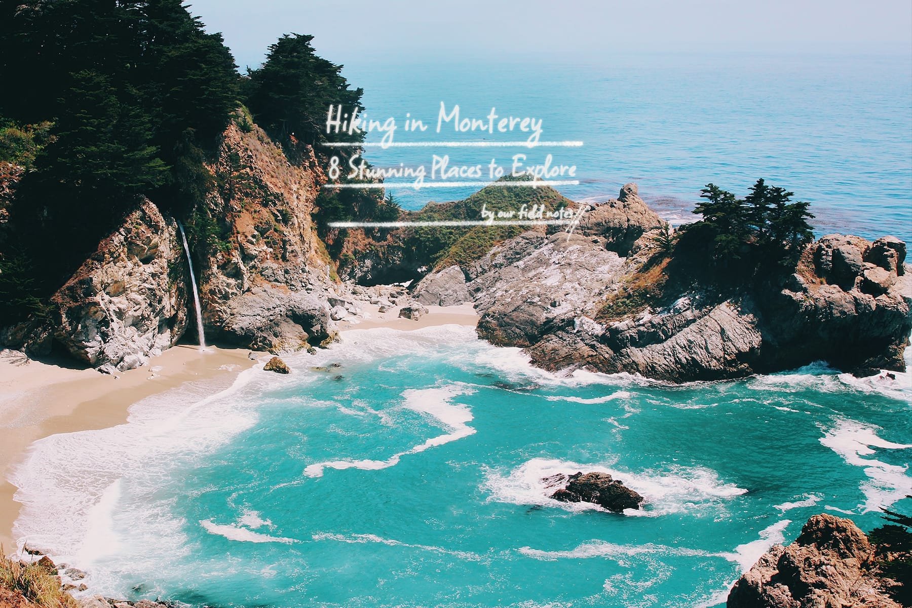
Home to ethereal forests, scenic drives, and millennium-old redwood groves, Monterey Bay is paradise on earth for lovers of the great outdoors. With thousands of acres of beautiful national parks and rugged coastal trails to embark on, the best way to explore Monterey is undeniably on foot.
As one of the top destinations along California's Central Coast, Monetary offers a ton of hikes through valleys and mountains that lead to breathtaking and dramatic coastal viewpoints. We've put together the complete guide to hiking in Monterey for all looking to explore California's natural beauty. So grab your notebook and pen—it's time to plan that trip to Monetary's most beautiful hiking spots!
1. Pfeiffer Big Sur State Park

Hiking in Monterey: Forest Path in Pfeiffer Big Sur State Park
The three state parks in the Big Sur region make for great hiking experiences in Monterey. The Pfeiffer Big Sur park is one of them, consisting of 8 hiking trails that go from 0.6 miles to 46 miles per round trip. Here are some of our favorite hikes of the bunch.
One of the most popular trails in the park by far is the Pfeiffer Falls Trail due to the grand display of cascading waterfalls you'll get. This moderately difficult 2-mile trail takes hikers on a steady incline up 200 feet through Redwood and Oak woodlands. Upon taking a left at the fork, there are another 300 feet to go till you reach the Valley View Overlook. From there, you can spot landmarks like Andrew Molera State Park (another Big Sur park), Point Sur Lighthouse, and the Big Sur River Valley. Once done, you'll want to head back and take the right fork to pass by Pfeiffer Falls, the 60-foot alluring beauty that's the centerpiece of the Pfeiffer Big Sur State Park. Check out the Pfeiffer Falls trail map for more information.
Another unique trail we recommend is Buzzard's Roos Trail. This moderate to high-level hike is a 3-mile roundtrip and takes you from the trailhead across the river from the Redwood Deck to the highest point, at an elevation gain of about 240 feet. Trekking along the Big Sur River and the shady redwoods, you'll eventually reach viewpoints with a sunny panoramic view of the sea, Santa Lucia Mountains, and the Sycamore Canyon. Along the way, a diversity of fauna, from towering redwoods to white globe lilies, greet you as you cross from one land space to another. Check out the Buzzard's Roos Trail map for more information.
The state parks charge $10 for a day pass, and they grant entry to all three parks if you enter them on the same day.
Last but not least is the Pfieffer Beach Trail. While this is technically not an official trail, we decided to include it in the list because it's possibly one of the best hikes in Big Sur due to the proximity you'll be to the rugged coast, where you'll be able to catch stunning coastal views. We recommend taking a stroll along the sandy beach up to the sea cliffs to experience hiking in Monterey and Big Sur to their fullest. A must-see sight when you're there is Pfieffer Beach's very own natural light show, AKA a fiery keyhole arch that looks incredibly gorgeous at sunset.

Hiking in Monterey: Pfieffer Beach Keyhole Arch at Sunset
Head over to the official Pfieffer Beach page for more information and directions to access the area.
Location: Pfeiffer Big Sur Rd, Big Sur, CA 93920
2. Julia Pfeiffer Burns State Park
The Julia Pfeiffer Burns State Park is another one of the three state parks in Big Sur. Named after the respected Big Sur pioneer, the Julia Pfeiffer Burns State Park stretches impressively from the Big Sur coastline into nearby 3,000-foot ridges.

Hiking in Monterey: The McWay Waterfall
Pfeiffer had a well-known affinity for the park's main attraction, the McWay Waterfall. Perfectly situated, this waterfall drops over a staggering granite cliff of 80 feet into a picturesque cove before flowing straight into the Pacific Ocean.
The park was also coined as "one of the four best spots to pitch a tent on the coast" by Sunset Magazine and for good reason. The variety of flora and fauna, combined with the numerous coastal overlook points, make the Julia Pfeiffer Burns State Park a trendy spot for those hiking in Monterey.
During the months of December, January, March, and April, wildlife lovers head to the park to witness the migration of whales. If you're lucky, you may even spot gray whales coming into the mouth of the cove. Scuba divers also frequent the underwater area of the park.
Hiking Trails
A well-loved trail at the Julia Pfeiffer Burns State Park is the Waterfall Overlook Trail. From the south parking lot or the steps near the entry booth, follow the trail directions towards Mcway Creek and through a tunnel beneath Highway One. The experience of going into the tunnel and coming out on the other side is like entering a whole different dimension, as you behold the light from the sun reflecting beautifully off the turquoise-blue ocean. The trail is short and vastly rewarding, at just under a mile, making it the easiest one on this list. It ends at an observation deck where you'll get 360-degree vistas of the Pacific Ocean.
A more underrated trail in the area is the Partington Canyon Trail, situated two miles North of the state park entrance. Divers commonly utilize this trail as it runs through a tunneled passageway to the beach.
To get to the park, you'll want to head south from Carmel for about 37 miles. It's located near marker 35.8 on Highway 1. Check out the official Julia Pfeiffer Burns State Park Page for more information.
Location: Pfeiffer Big Sur Rd, Big Sur, CA 93920
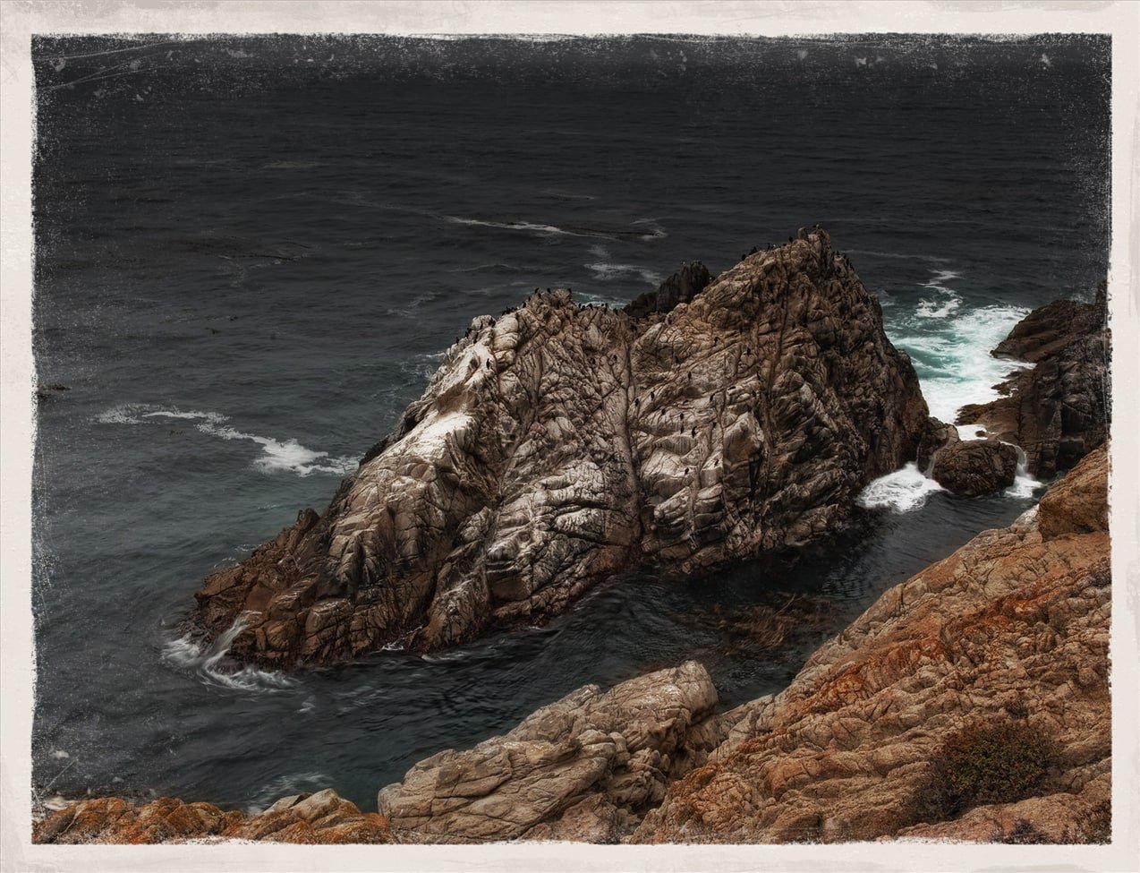
3. Point Lobos State Natural Reserve
The Point Lobos State Natural Reserve has a range of incredible hiking trails that are fit for a novice or experienced hikers. The beautiful promontory, Point Lobos, has been coined "the crown jewel of the state park system" because of its gorgeous coastal vistas, excellent hiking and diving spots, and interesting features like an old whaler's cabin.
The location is also great for watching wildlife, such as the migration of gray whales, or simply having a picnic with friends or family.
Hiking Trails
The Point Lobos Loop Trail is a 5.1-mile trail that takes you on a journal through several trails, such as the Point Lobos, Cypress Grove, Sea Lion Point, and Bird Island trails. You'll also catch fantastic views from lookouts such as Weston Beach, Cannery Point, and China Cove along the way. Exciting wildlife, such as sea lions, lizards, and sea birds, can all be spotted from some of these points.
The Cypress Grove Loop Trail alone leads you through a natural cypress grove where you'll have a chance to stroll alongside spectacular seaside cliffs for most of the journey. To hike this trail, you'll want to go counter-clockwise from the parking lot at Whaler's Cove and make a big loop along the coast. The elevation gain is about 348 feet.
Hiking in Monterey: Point Lobos
Fun Fact: "Point Lobos" came from its Spanish name, "Punta de Los Lobos Marinos," which also translates to "Point of the Sea Wolves." The title references the presence of sea lions near the reserve.
This excellent hiking spot is pretty accessible—just drive south on Highway 1 from Carmel, and you'll get there in about 4 miles.
Once you've completed the hike, remember to stop by the Whalers Cabin museum, built by Chinese immigrants in the 1850s. There, you'll have a chance to check out giant old whale bones, intriguing artifacts, and discover more about the area's rich history.
Address: 62 CA-1, Carmel-By-The-Sea, CA 93923
4. Limekiln State Park

Hiking in Monterey: Pitkins Curve Bridge, Route 1 near Limekiln State Park
Limekiln State Park is a 711-acre park containing four lime kilns from an 1887–1890 lime-calcining operation. As one of Big Sur's hidden gems, the park is tucked away in the steepest coastal canyon in continental US, two miles south of Lucia.
Like some of the other state parks on this list, it also contains some signature sights you'll get when hiking in Monterey. Namely, tall redwood trees and a waterfall. In a previous article, we covered the trail route to Limekiln Falls, a 100-foot-tall waterfall and refreshing sight to come across when you're adventuring around the state park.
Hiking Trails
As you enter, you may walk along Limekiln Creek upstream to reach the Limekiln trailhead. This trail will take you to the abandoned lime kilns synonymous with the park. Upon crossing a footbridge that transports you to the other side of the creek, you'll soon arrive at a trail fork. Keep left, and you'll eventually find yourself standing amongst the impressive steel and stone kilns that once converted limestone into lime.
If you've got a little more adventure left in you, head back to the fork and take the right-lane path. This will take you up to Hare Creek, where you'll experience more of the redwood lifecycle along the way. Bask in a series of young redwoods that are only about a century old. You'll then reach a grove of mature redwoods that are one to two thousand years old towards the end of the trail.
Check out the official Limekiln State Park website for more information.
Location: 63025 CA-1, Big Sur, CA 93920
5. Garrapata State Park

Hiking in Monterey: Views form the bluff trails at Garrapata State Park
Some of the best hikes in Monterey can be found in lesser-known spots. Located south of Point Lobos State Natural Reserve, the Garrapata State Park is where acres of untouched forests make for an authentic retreat into nature. Redwood-filled canyons and trails that lead you to stupendous views of the Big Sur coastline are just some highlights you'll miss out on if you drive past this scenic beauty toward some other destination.
Hiking Trails
The Garrapata State Park is along Highway 1, 6.7 miles south of Rio Road in Carmel and 18 miles north of Big Sur. It’s easy to miss if it's not already in your plan to head there. To find it, you'll want to look out for the Garrapata State Park sign and a large pullout shortly after under a row of cypresses. Once you've parked, head towards the dirt path and tin barn, which is also the trailhead for the 1.25-mile Soberanes Canyon Trail. This popular out-and-back hike will take you to the back of the canyon.
If you take the Soberanes Point to Whale Peak trail instead, you'll easily come across wildlife such as harbor seals, sea lions, and sea otters. Ironically, whales are harder to spot there but hey, there's no harm in trying your luck. There are quite a few flights of stairs in certain portions of the Whale Peak Trail, closer to the PCH, so make sure you're well-prepared for that. But as long as you're in decent shape, it shouldn't be a problem.
Pro tip: For an elevated hiking in Monterey experience, head to the Garrapata State Park during the months of Spring and Summer to see beautiful wildflowers in full bloom and experience the refreshing cool sea breeze.'
Do note that the Rocky Ridge portion of the trail may be closed due to hazardous conditions. Check out the official Garrapata State Park page and trail maps for more information.
Location: 34500 CA-1, Carmel-By-The-Sea, CA 93923
6. Jack's Peak County Park

Hiking in Monterey: Views from Jack’s Peak
If you're a beginner, hiking in Monterey doesn't get much better than Jack's Peak County Park. The relatively smaller but impressively high elevation is what sets it apart from other features on this list. Jack's Peak is actually the highest point in the entire Monterey peninsula—elevated at slightly over a thousand feet on the hills of Monterey. This makes for some guaranteed good views of Monterey and Carmel from above.
Hiking Trails
For a leisurely stroll through the park, we'd recommend parking at the designated lot close to Jack's Peak first. After that, take the Jacks Peak trail, a short 0.6-mile in-and-out hike that lets you witness the last remaining strands of Monterey Pines and incredible wildlife, such as the California banana slug. You can spot the Old Fisherman's Wharf at Jack's Peak, along with the Carmel Highlands.
If you've got a taste for a little more rigor, take the 0.8-mile Skyline Nature Trail instead. You'll see an information board near some picnic tables in the parking lot. Grab a flyer for the Skyline Nature Trail there and head left to start embarking on the well-marked trail. Along the way, you'll pass a rocky tunnel where you can see some fascinating fossils of sea creatures. In about 0.2 miles from the trailhead, you'll get sweeping views of Monterey Bay, and about 0.2 miles after, Carmel Valley and Point Lobos will be within sight.
Once you're done with your hike, take a left on Iris Trail to return to the parking lot where you started. Alternatively, go right on the Iris Trail and follow it to the Rhus Trail to add about another 1.8 miles of splendid views to your hike. Afterward, you can make a left to return to the parking lot.
Head to the official Jacks Peak County Park page for more information and detailed trail maps. The entrance fee is $5 per vehicle, and admission to the park costs $2 per person, so make sure to bring some cash with you.
While the park is typically packed on the weekends, it's virtually deserted on weekdays. So if some peace and quiet are what you're looking for, schedule a hike at Jacks Peak County Park on one a weekday!
Location: 25020 Jacks Peak Park Rd, Monterey, CA 93940
7. Monterey Bay Coastal Recreational Trail

The Monterey Bay Coastal Recreational Trail is another good option to consider if you're looking for some of the best hikes in Monterey to soak in ocean views. The 18-mile-long waterfront trail stretches all the way from Castroville north to Pacific Grove, and can be experienced either on bike or by foot. The roughly 2-mile-long section between the Old Fisherman's Wharf and Lovers Point is a favorite amongst many visitors.
The trail also offers several spots for you to stop by and grab a bite to eat on your journey. You can also have a picnic on one of the trail's many grassy spots, against the backdrop of the beautiful Monterey Bay.
Map of the Trail
The Monterey Bay Coastal Trail is also a great way to access several attractions, such as the Monterey Bay Aquarium, the American Tin Cannery outlet mall, Cannery Row, and more. The best part? You'll get to avoid pesky traffic and the woes of finding parking by going on foot.
If sticking to natural sights is more your thing, head down to Asilomar State beach, a one-mile strip of sandy beach and rocky coastline in Pacific Grove, CA.
8. Pinnacles National Park
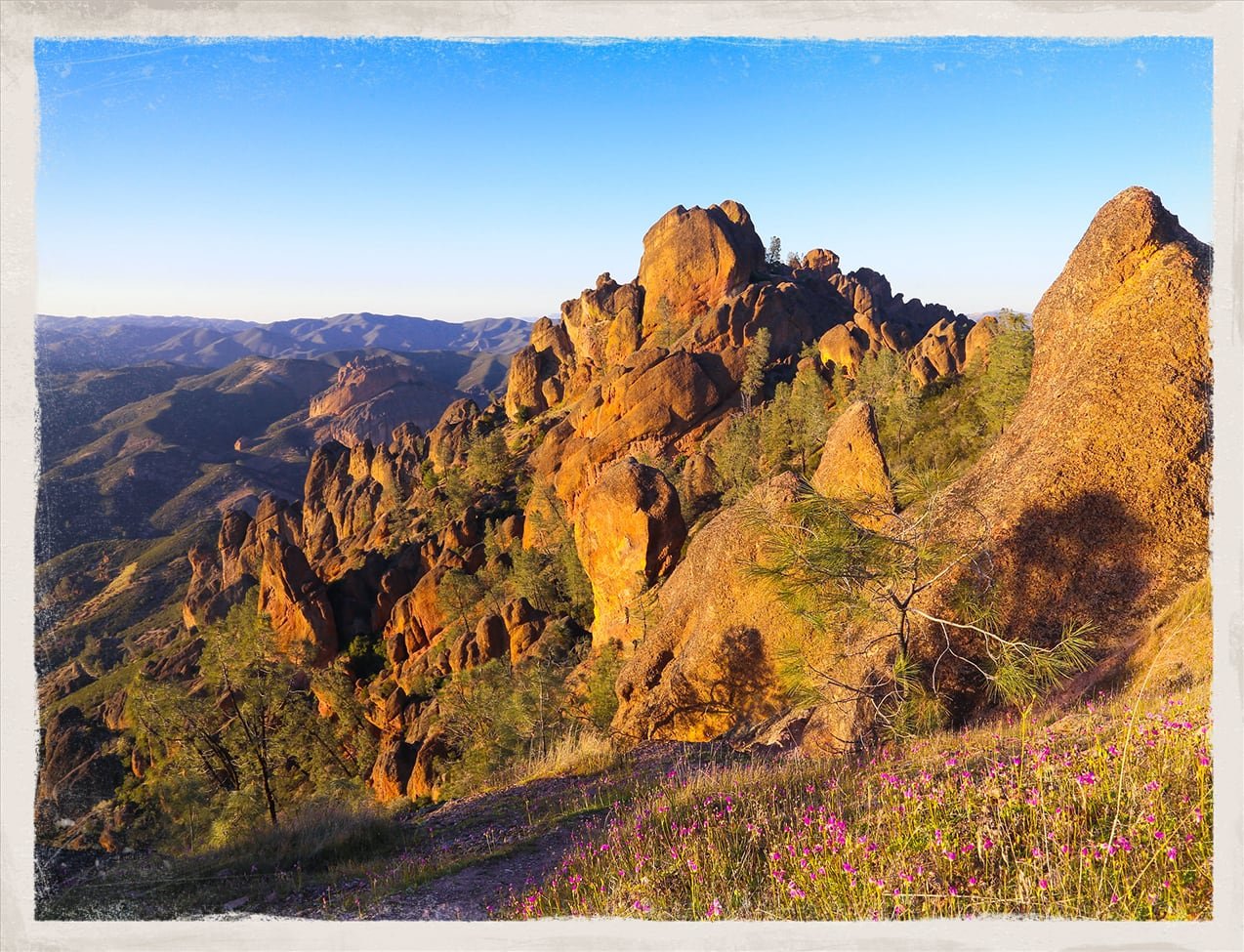
Hiking in Monterey: Golden hour at Pinnacles National Park
Last but not least is Pinnacles National Park. As the region's one and only national park, this inland-located park serves to protect the mountainous area located east of the Salinas Valley in Central California.
While it'll be a slight change of scenery from the coastal hikes on this list, filled with beautiful beaches and dramatic cliffs, we promise the views at Pinnacles National Park are equally captivating. As you go along the 30 miles of trails available, witness the aftermath of multiple volcano eruptions from some 23 million years ago, where lava flowed into the area we now know as the state park. The eruptions gave rise to many of the park's unique features, such as rocky formations, chaparral, caves, oak woodlands, and canyon bottoms.
Map of Pinnacles National Park
If you're looking for something moderate in difficulty, go for the 2.2-mile-long Moses Spring Trail loop, which is the perfect fascinating, and educational hike for families. The hike begins at the Bear Gulch Day Use Area, where you can pick up a copy of the interpretive trail pamphlet at the visitors' center nearby before starting. The trail begins at a nicely-shaded region before running through a small rock tunnel. After that, you can take the Bear Gulch Cave Trail that leads you to—surprise, surprise—Bear Gulch Cave. Do note that it's only open during certain seasons, though.
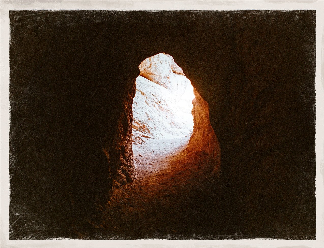
Hiking in Monterey: Bear Gulch Cave
Pro Tip: Make sure you bring a torch light if you're keen on exploring the talus cave.
If Bear Gulch cave isn't open when you're there, don't worry— your cave-seeking dreams are not crushed. Continue on the Moses Spring trail. You'll ascend higher into smaller but still-intriguing caves underneath a giant boulder wedged permanently between two stone walls. Once you've explored the area, take the set of stairs that lead you up to Bear Gulch Reservoir. The Rim Trail will take you back into the parking lot.
On their official page, you can find a complete list of the trails available for getting to and around Pinnacles National Park.
Gear Tips and Checklist

Hiking shoes
Weather-appropriate Clothing
Water Bottle
Sunglasses or Hat
Granola Bars or Trail Mix
Packed Sandwich for a full-day hike
Cash for Park Entries
Nearby Attractions
Hiking in Monterey is all but one of the many ways to enjoy the beautiful country and wider Big Sur. We've put together some other exciting activities to check out when you're there.