Stonewall Panoramic Trail - The Complete Hiker’s Guide

Introducting the Stonewall Panoramic Trail

Night View from the Claremont Canyon Regional Preserve | Flickr
Located in the Claremont Canyon Regional Preserve, the Stonewall Panoramic Trail is a quick but rewarding hike that offers stunning panoramic views of Bay Area almost throughout the whole journey. What makes this trail unique amongst other trails in the Berkeley, California area is that it offers the best of both worlds—you'll get to be in nature while still being close to the urban flatlands of Oakland and Berkley.
There was a time when Huchiun Ohlone Indians inhabited the Claremont Canyon region, using it as grounds for their hunting and gathering activities. Today, it's a popular place amongst hikers, horseback riders, and sightseers looking to get breathtaking views of the city from above.
If you're looking for a quick retreat to nature that'll get your blood pumping with some cardio, this trail is the one for you.
Key Information
The trail's difficulty level is on the moderate-to-high side, with steep hills and occasional loose, rocky paths. If you're a seasoned hiker with the right gear, this trail should be relatively manageable. However, this isn't the trail for those simply looking for an easy nature trail to breeze through. (Though the views are well worth the arduous journey—we promise!)
Distance: 1.5 miles out-and-back
Average Time to Complete: 1 hour, 10 minutes
Elevation Gain: 663 ft
Park Operating Hours: 5 a.m. to 10 p.m.
Pet Policy: Dogs allowed, but must be on leash in most areas (Note that ticks are common in the Claremont Canyon Regional Preserve, so be wary)
The trail is also very popular, especially on the weekends. You may pass fellow hikers every 2-3 minutes then, though you can always go in the afternoon on a warm day if you're seeking a peaceful hike with fewer crowds.
The Hiking Experience
Welcome To The Park
Start at the trailhead located on Stonewall Road. As you enter the park, keep to the right, and you'll find where the trail starts. The first half of the trail travels through a eucalyptus grove, and your fight against gravity begins as the path gradually increases in steepness. At the first switchback, you'll be able to catch a nice view of UC Berkley through a break in the trees. The higher you climb, the more the scenic view of the city opens up dramatically.
About one-third away from reaching the peak, you'll see a sign warning hikers of the steep trail ahead. At this point, you may feel the urge to glance back and wonder, "Was I not already on the steep part of the trail?"
Alas, with enough strength, willpower, and inevitable sweat, you'll eventually reach the trail's final leg, which leaves the woods behind and travels up to the top of the hill. Be extra careful here, as the rocky dirt road can be slippery at times.
For your efforts making it up the 0.7-mile incline, you'll be rewarded with a breathtaking view of San Francisco from above, comparable to the one from Christmas Tree Point on Twin Peaks.
On a clear day, you'll get a birds-eye view of both the Golden Gate bridge and the Bay Bridge. Other visual highlights include the Marin Headlands, Mount Tamalpais, Richmond, and the sweeping views of downtown Oakland and Berkley.
There's also a sweet little bench there for visitors to rest and take in the view. Fingers crossed, it's not occupied when you're there.
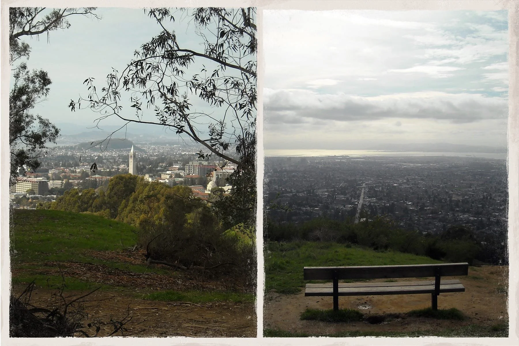
Views from the top of the Stonewall Panoramic Trail
From this point, you'll have two options:
Retrace your steps back to the trailhead to complete your Stonewall Panoramic Trail experience or
Continue on and turn left into Panoramic Way, a paved path that connects to the rest of Claremont Canyon Regional Preserve's trails.
If you choose the second option, you could take the Fire trail and go through Panoramic Road to complete the loop.
Alternatively, another popular route is to head down the unofficial trail that leads to the Clark Kerr UC Berkley campus. If you've still got more energy left in you, there's also a workout station with bars where you can end your hike with some strength training.
While the Stonewall Panoramic trail is no walk-in-the-park for casual hikers, you'll find plenty of unmarked spots along the way where you can rest your feet and take in the view, before continuing.
Wildlife in the Stonewall Panoramic Trail
Throughout the trail, you'll come across various interesting flora and fauna. The plant species scattered throughout the trail include California sagebrush oak, bay laurel, and eucalyptus trees, amongst many others. You might also cross paths with a few animals, including coyotes, gray foxes, black-tailed deer, and red-tailed hawks.
Some hikers have reported spotting rattlesnakes when on this trail, so keep a safe distance from them if you encounter any. If you do, fingers crossed you live to tell the tale on your 1-star Google review of the trail.
Getting There
Location of the Stonewall Panoramic Trail
Driving Directions to the Stonewall Panoramic Trail
If you're taking Highway 24 to reach the trailhead, you'll want to exit from Fish Ranch Road east of the Caldecott Tunnel. Then, drive a mile up Fish Ranch Road to the four-way stop. Continue through to Claremont Avenue for about 3 miles more. To reach the trail entrance, turn right into Stonewall Road and travel for about a quarter mile more.
If you're taking Highway 13 instead, turn east onto Claremont Ave in Berkeley and go on for about a quarter mile. Once you've made it to Stonewall Road, make a left. You'll find the Claremont Canyon preserve's main entrance just behind the Claremont hotel. You can park along Stonewall Road, near the trailhead, but note that spaces are limited on this narrow street.
Public Transit to the Stonewall Panoramic Trail
The AC Transit routes #7, and #9 run along Ashby Avenue and Claremont Avenue. The closest stop, Russell St/Claremont Blvd, is about 0.75 miles from the trailhead. Nothing like a good pre-trail warmup, right?
For more information on the Claremont Canyon Regional Reserve and how to access it via public transit, visit their official website.
Insider Tips
Best Time To Hike
While the Stonewall Panoramic trail is accessible pretty much throughout most of the day, we recommend going during sunset hours to catch the best views of orange light casting over the San Francisco skyline. If you do happen to go during nightfall, keep an ear out for great horned owls sounding their mating calls into the night.
If you'd prefer a little more solitude, the best time to go would be the early mornings on a weekday.
Grab a Pre-Hike or Post-Hike Snack
Before or right after embarking on your hike at the Claremont canyon regional preserve, you may want to fuel up on some of the most scrumptious pastries in Bay Area. Located within a block from the hike, a petite french bakery known as Fournée Bakery serves a delectable spread of sweet and savory pastries, bread, and pizza slices. We hear the Ham and Manchego croissant is a crowd favorite, so give it a go if you do drop by.
Gear Tips & Checklist

As descending from the hill can get a bit dangerous at slippery parts from loose gravel, we recommend you wear sturdy hiking shoes. If you're knees or ankles are particularly vulnerable, use a pole for additional support.
Here's a complete list of recommended gear tips:
Hiking Footwear
Hiking pole
Sunscreen and hat (the trail is relatively unshaded at the start)
Water bottle
Phone or Camera